Tropical Cyclones (TCs)
There has been a major improvement in tropical cyclone (TC) track forecasting in the past decade. However, prediction of TC intensity change and rainfall is still challenging, and of immense practical importance. One of the critical questions in TC research is what the necessary and sufficient conditions are for TC intensification, and especially rapid intensification (RI). Favorable large-scale environmental conditions that are near-universally agreed to be necessary include: warm sea surface temperature (SST), high low- to mid-level moisture, and low vertical wind shear. Other factors such as high ocean heat content (Shay et al. 2000), enhanced heat and moisture flux (Bosart et al. 2000), and whether a TC is well below its maximum potential intensity (Kaplan and DeMaria 2003) were also found to be related to RI. Defining sufficient conditions is still controversial, especially the possible role of intense convective events. Early studies suggested that hot towers (Simpson et al. 1998) and convective bursts (Steranka et al. 1986) near the eye are related to TC intensity change. Recent modeling studies (Hendricks et al. 2004, and Montgomery et al. 2006) proposed that intense vortical hot towers may be a missing link in the chain of events that transforms a mid-level vortex into a near-surface vortex, initiating TC genesis and perhaps also RI. This model-based result needs to be evaluated by observational studies not only on a case-study base, but more importantly in a statistical manner. A previous observational study (Cecil and Zipser 1999) presented evidence that a relationship exists between intense convection and TC intensity using the 85 GHz ice-scattering signature observed by SSM/I, but that the total rain rate in the inner core has a better relationship. Recent observational studies also found that the chance of TC intensification increases when one or more hot towers exist in the eyewall using a limited subset of TRMM precipitation radar data (Kelley et al. 2004) and WSR-88D radar data (Kelley et al. 2005). Yet uncertainties remain and additional quantification with a larger database is highly desirable.
In recent decades, fresh water flooding has become one of the main threats to human life when a TC makes landfall (Rappaport 2000). The rainfall climatology and persistence model (R-CLIPER, Tuleya et al. 2007) is one of the major tools used by the National Hurricane Center (NHC) for TC rainfall forecasts. The operational R-CLIPER uses radial distributions of azimuthally averaged TC rain rates derived from satellite to construct an instantaneous rainfall footprint as a function of storm intensity (Lonfat et al. 2007). The improvement of the statistical rainfall prediction technique highly relies on satellite-based rainfall estimations.
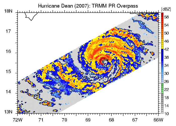
The Tropical Rainfall Measuring Mission (TRMM, Kummerow et al., 1998) marks the first time that TCs in all ocean basins can be viewed by high resolution down-looking precipitation radar. After 12 years of successful operation, TRMM measurements, along with other NASA satellite measurements such as QuikSCAT and numerical model-based reanalysis, have provided invaluable sources of TC data for the study of TC intensification, rainfall, and environment. The University of Utah TRMM Precipitation Feature database (UU TRMM PF) provides a very useful tool to analyze convective intensity over the global tropics using several TRMM-observed proxies. For studying TCs, a subset of the UU TRMM PF database is built, called the Tropical Cyclone related Precipitation Feature (TCPF) database, with TC best track information incorporated into it.
The TRMM TCPF database and the NASA Hurricane Science Research Program (HSRP)
For more than a decade, the NASA Convection And Moisture EXperiment (CAMEX) series of field campaigns have provided a wealth of new research findings into the genesis, intensity change, and 3D multiscale structure of tropical cyclones in the Atlantic, Gulf of Mexico and Eastern Pacific ocean basins. The CAMEX sequence (CAMEX-3, 1998; CAMEX-4, 2001; TCSP, 2005; NAMMA, 2006; GRIP, 2010 as planned) has also consistently provided a test-bed for new remote sensing technologies for satellite and aircraft platforms, retrieval algorithms, and predictive model developments. Apart from these field experiments, there is a wealth of data available from NASA research satellites such as TRMM, Aqua, QuikSCAT, Jason etc. These satellite data has been used in isolated case studies of hurricanes and intensity forecasts and needs further exploitation in conjunction with the field experiment data to develop a more robust understanding of hurricane behavior. The TRMM TCPF database is to provide TRMM-based TC data in a common framework and to make it available to the NASA HSRP science team for TC studies. This webpage is dedicated to providing a searching tool of the past TRMM (and possibly future GPM) observations in TCs and distributing some general scientifically ready products to the public from the TRMM TCPF database.

|
TCs viewed by TRMM You will be able to access each storm for six TC-prone basins viewed by TRMM since its launch in late 1997. The six basins are: North Atlantic (ATL), Eastern and Central Pacific (EPA), Northwestern Pacific (NWP), Northern Indian Ocean (NIO), Southern Indian Ocean (SIO), and South Pacific (SPA). In this website, TRMM overpasses are listed one by one for each storm. Images and data of each TRMM orbit and images of 3B42 rainfall accumulation for each storm are available for download.
|
